


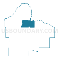
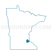
Rosemount P-2, Dakota County, Minnesota
About
Outline

Summary
| Unique Area Identifier | 601745 |
| Name | Rosemount P-2 |
| County | Dakota County |
| State | Minnesota |
| Area (square miles) | 28.75 |
| Land Area (square miles) | 27.11 |
| Water Area (square miles) | 1.63 |
| % of Land Area | 94.32 |
| % of Water Area | 5.68 |
| Latitude of the Internal Point | 44.74237140 |
| Longtitude of the Internal Point | -93.04751640 |
Maps

Graphs
Select a template below for downloading or customizing gragh for Rosemount P-2, Dakota County, Minnesota


Neighbors
Neighoring Voting District (by Name) Neighboring Voting District on the Map
- Coates Voting District, Dakota County, MN
- Cottage Grove P-2, Washington County, MN
- Eagan P-20, Dakota County, MN
- Empire Twp. Voting District, Dakota County, MN
- Inver Grove Heights P-2, Dakota County, MN
- Inver Grove Heights P-3, Dakota County, MN
- Nininger Twp. Voting District, Dakota County, MN
- Rosemount P-1, Dakota County, MN
- Rosemount P-4, Dakota County, MN
- Rosemount P-6, Dakota County, MN
- Vermillion Twp. Voting District, Dakota County, MN
Top 10 Neighboring County Subdivision (by Population) Neighboring County Subdivision on the Map
- Eagan city, Dakota County, MN (64,206)
- Cottage Grove city, Washington County, MN (34,589)
- Inver Grove Heights city, Dakota County, MN (33,880)
- Rosemount city, Dakota County, MN (21,874)
- Empire township, Dakota County, MN (2,444)
- Vermillion township, Dakota County, MN (1,192)
- Nininger township, Dakota County, MN (950)
- Coates city, Dakota County, MN (161)
Top 10 Neighboring Place (by Population) Neighboring Place on the Map
- Eagan city, MN (64,206)
- Cottage Grove city, MN (34,589)
- Inver Grove Heights city, MN (33,880)
- Rosemount city, MN (21,874)
- Coates city, MN (161)
Top 10 Neighboring Unified School District (by Population) Neighboring Unified School District on the Map
- Rosemount-Apple Valley-Eagan School District, MN (143,932)
- South Washington County School District, MN (92,998)
- Hastings Public School District, MN (31,627)
- Inver Grove Heights Schools, MN (28,850)
Top 10 Neighboring State Legislative District Lower Chamber (by Population) Neighboring State Legislative District Lower Chamber on the Map
- State House District 36B, MN (50,199)
- State House District 37B, MN (44,374)
- State House District 57B, MN (41,159)
- State House District 39B, MN (40,778)
- State House District 57A, MN (40,488)
- State House District 38B, MN (36,363)
Top 10 Neighboring State Legislative District Upper Chamber (by Population) Neighboring State Legislative District Upper Chamber on the Map
- State Senate District 36, MN (96,657)
- State Senate District 37, MN (84,536)
- State Senate District 57, MN (81,647)
- State Senate District 39, MN (77,255)
- State Senate District 38, MN (73,200)
Top 10 Neighboring 111th Congressional District (by Population) Neighboring 111th Congressional District on the Map
Top 10 Neighboring Census Tract (by Population) Neighboring Census Tract on the Map
- Census Tract 714, Washington County, MN (7,003)
- Census Tract 610.04, Dakota County, MN (6,116)
- Census Tract 607.32, Dakota County, MN (5,762)
- Census Tract 605.08, Dakota County, MN (5,716)
- Census Tract 605.09, Dakota County, MN (5,441)
- Census Tract 610.09, Dakota County, MN (5,198)
- Census Tract 610.07, Dakota County, MN (4,965)
- Census Tract 610.01, Dakota County, MN (3,455)
- Census Tract 610.08, Dakota County, MN (1,864)
- Census Tract 610.03, Dakota County, MN (1,329)
Top 10 Neighboring 5-Digit ZIP Code Tabulation Area (by Population) Neighboring 5-Digit ZIP Code Tabulation Area on the Map
- 55016, MN (34,204)
- 55024, MN (32,406)
- 55033, MN (29,488)
- 55068, MN (27,490)
- 55123, MN (26,030)
- 55076, MN (21,323)
- 55077, MN (12,572)